 |
 12-25-2007, 07:30 AM
|
#1
|
|
Admiral
Join Date: Oct 2004
Posts: 3,067
|

Here is a 1st hand report on Muar - which has the potential to be a very desirable first port of call on the journey northward in the Strait of Malacca.
John Rand on the Cruising yacht "Dancyn" has provided today the following on his call into Muar
(see also the 7 Dec. Post in the topic where "Dancyn" proceeded to assist the Cruising Yacht "No Komis" which was in trouble in the Northern Java Sea :-
http://www.cruiserlog.com/forums/index.php?showforum=51 )
John needed to clear in to Malaysia, whilst at the same time dropping off a crew member who had to catch a flight - inquiries were put out into the cruising fraternity to find somewhere closer than Port Dickson - Yachtie in Bonbanon - Negros , the southern Philippines suggested Muar :-
"Hey Richard
I am getting close to pick you up on 14meg. You sound busy,lots of folks on the move! Here is a write up on Muar, hope you can post it so others can access it.
Dec 25 2007
Muar is a perfect stop over for those wishing to skip Singapore, wish to provision and rest or just check out a nice and friendly Malaysian town. Muar has a 1hr bus to Malaka for 11 rm,singapore 3.5hrs 16 rm as well as connections to KL and beyond. Muar has a one stop shop for immigration/customs/harbor master with its' own wharf suitable for yachts(I slept there one night). It is a smallish city with all that a cruiser could need. It has a nice veg/meat/fish market as well as several super markets.
The best supermarket and open market are next to one another past the bridge at the second bus station. Several shopping centers,restaurants and endless open food vendors litter the city and are a short walk away. Muar has a pleasant and tidy riverfront park with an esplanade and a beautiful blue Mosque making this lovely middle class town worth the stop.
I was north bound from Indonesia and crossed the Malacca Straight shipping lanes at the narrowest point just west of Singapore. In one day I made it to Muar and anchored out for the night at the river mouth. It was a very mellow evening and I rested well. I can not comment on the area in a strong wind as it was still both times I was there. I anchored very close to the most southeastern green marker in 20ft of sand/mud. In the morning at the lowest 3rd of the tide I proceeded to the second red and
green markers at the entrance of the bar. I had less than 5.5 feet and turned around. The area before and after the 2 markers is the shallowest section of the the run into town. the Sailing Directions state it has 1.2 meters at low water. I entered at 1.5hrs before high water on a rising tide and had 7 to 9 ft of water. The cross current was strong. Once between the red and green you can sight down to the orange marker mid channel to the east 100T. It has a working red light on it. There is a white
tower off to port of the orange marker,I have no idea what it is for. It is a long run to the orange marker, the marina entrance is to starboard behind the concrete wall. The upstream wall is washed away as well as the upstream pontoons. Proceed past the marina and the 12 yellow mooring balls. There are several wharfs to starboard before the bridge. After the Polis Wharf(navy blue/white boats with POLIS written on them),Customs wharf(camouflage speedboats with CUSTOMS on them)and the ferry wharf
the is the Immigration/Harbor Master's wharf(white steel 15 meter boat)It is the last big wharf before the bridge. Space allowing any of these wharfs would be possible and allowed for the check in procedure. I was instructed to tie up to the Harbor master's white boat. It was perfect. The white ships cleats were at the perfect hight and I did not have to account for tide. The downstairs is Immigration, once finished there go upstairs to see the harbor master. Then go one building to the west and
let the custom officer tell you he does not need to see you like he told me. The Harbor master offered me a mooring free of charge. The river was a steady 20ft and one could anchor and use the immigration wharf for the dingy. There are guards 24/7 and the gates are unlocked. Moven, a customs officer extended an invitation to post his number when he and his family took me out to dinner. Any questions and you can give him a call 0176162240 he is a nice fellow with an excellent command of English. Marine
department/Harbor master 0695522477.
Jetty Marina was washed out by heavy flooding. When operational it must have been a very fancy/up market facility. I stayed there and found 9ft of water at low water in the outer most pontoons. There was one power boat there mid pontoon. Matzalan is the care taker of the facilities. He did not know what to charge. We agreed on 20 rm for my 32 ft sailboat. He would have not charged me to stay on a mooring and use the dock there for my dingy. The showers were locked and he had no key. The water and
electricity were turned off. There was a men's toilet. The complex has been purchased with the intentions to turn it into a one stop fuel,clearance stop. I stayed for 3 nights. the guards let many people come out onto the pontoons and wharfs to fish at night. I had no problems and did not feel the urge to lock anything. The guards were happy to give me a lift in to town but it was only a 15 min walk. The river walk is alive with people until late and is always safe.
I took gps positions on the way OUT of Muar. I hesitate to give them as the nav aids are clear and there is plenty of traffic to follow. These are the 5 way points and the depths at 1.5 before high tide on dec 22 2007 at 6am.
#1 n0203.038,e10233.152 orange marker 19ft #2 n0203.279,e10232.118 midway down channel 9ft,#3 n0203.369,e10231.685 10ft, strongest tide,#4 n0203.490,e10231.140 red and green nav markers about 300 meters apart both lit with good radar returns 9ft. At this time they were dredging. The dredging barge may obscure the lights at night. #5n0202.555,e10230.635 outermost green marker. safe to anchor and wait for the light or tide. 20ft sand mud.
regards
John Rand s/v DANCYN ki4wfpATwinlink.org"
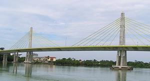
The New Bridge across the River Muar :-
__________________
__________________

|

|

|
|
12-25-2007, 11:43 AM
|
#2
|
|
Admiral
Join Date: Oct 2004
Posts: 3,067
|
Could someone rework the Lat/longs for this excellent posting.
Richard
__________________
__________________
|
|
|
|
|
12-25-2007, 03:17 PM
|
#3
|
|
Admiral
Join Date: Jul 2004
Posts: 2,098
|
Quote:
Originally Posted by MMNETSEA

#1 n0203.038,e10233.152 orange marker 19ft #2 n0203.279,e10232.118 midway down channel 9ft,#3 n0203.369,e10231.685 10ft, strongest tide,#4 n0203.490,e10231.140 red and green nav markers about 300 meters apart both lit with good radar returns 9ft. At this time they were dredging. The dredging barge may obscure the lights at night. #5n0202.555,e10230.635 outermost green marker. safe to anchor and wait for the light or tide. 20ft sand mud.
regards
|
#1: 02 03.038'N, 102 33.152'E
#2: 02 03.279'N, 102 32.118'E
#3: 02 03.369'N, 102 31.685'E
#4: 02 03.490'N, 102 31.14'E
#5: 02 02.555'N, 102 30.635'E
Google Earth is a great resource for checking somebody else's coordinates, I think. It is so easy to make a mistake, such as putting "W" instead of "E" into the GPS. So close to the equator here, "S" rather than "N" (or vice versa) is so easy to do.
|
|
|
|
|
12-28-2007, 10:45 PM
|
#4
|
|
Admiral
Join Date: Oct 2004
Posts: 3,067
|
Quote:
Originally Posted by JeanneP
#1: 02 03.038'N, 102 33.152'E
#2: 02 03.279'N, 102 32.118'E
#3: 02 03.369'N, 102 31.685'E
#4: 02 03.490'N, 102 31.14'E
#5: 02 02.555'N, 102 30.635'E
|
Jeanne , thanks very much for the rework !
For those that need the full degrees, minutes and seconds format in their GPS's, here is Jeanne's rework plus the seconds :-
#1: 02º 03' 2.3" N x 102º 33' 9.1" E
#2: 02º 03' 16.7" N x 102º 32' 7.1" E
#3: 02º 03' 22.1" N x 102º 31' 41.1" E
#4: 02º 03' 29.4" N x 102º 31' 8.4" E
#5: 02º 02' 33.3" N x 102º 30' 38.1" E
Richard
__________________
|
|
|
|
|
|
Currently Active Users Viewing This Thread: 1 (0 members and 1 guests)
|
|
|
 Posting Rules
|
You may not post new threads
You may not post replies
You may not post attachments
You may not edit your posts
HTML code is Off
|
|
|
|
 Recent Threads
 |
|
|
|
|
|
|
|
|
|
|
|
|
|
|
|
|
|
|
|
|
|
|
|


 Linear Mode


