WTPS31 PGTW 131500
MSGID/GENADMIN/NAVMARFCSTCEN PEARL HARBOR HI/JTWC//
SUBJ/TROPICAL CYCLONE 20P (ULUI) WARNING NR 005//
RMKS/
1.
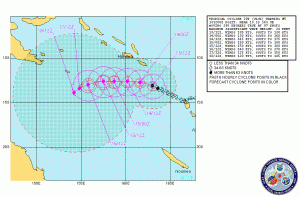
TROPICAL CYCLONE 20P (ULUI) WARNING NR 005
02 ACTIVE TROPICAL CYCLONES IN SOUTHPAC
MAX SUSTAINED WINDS BASED ON ONE-MINUTE AVERAGE
WARNING POSITION:
131200Z --- NEAR 13.1S 163.0E
MOVEMENT PAST SIX HOURS - 295 DEGREES AT 07 KTS
POSITION ACCURATE TO WITHIN 020 NM
PRESENT WIND DISTRIBUTION:
MAX SUSTAINED WINDS - 105 KT, GUSTS 130 KT
---
FORECASTS:
12 HRS, VALID AT:
140000Z --- 12.7S 161.6E
MAX SUSTAINED WINDS - 130 KT, GUSTS 160 KT
WIND RADII VALID OVER OPEN WATER ONLY
VECTOR TO 24 HR POSIT: 275 DEG/ 07 KTS
---
24 HRS, VALID AT:
141200Z --- 12.6S 160.2E
MAX SUSTAINED WINDS - 145 KT, GUSTS 175 KT
VECTOR TO 36 HR POSIT: 270 DEG/ 07 KTS
---
36 HRS, VALID AT:
150000Z --- 12.6S 158.7E
MAX SUSTAINED WINDS - 150 KT, GUSTS 180 KT
VECTOR TO 48 HR POSIT: 270 DEG/ 06 KTS
---
EXTENDED OUTLOOK:
48 HRS, VALID AT:
151200Z --- 12.6S 157.5E
VECTOR TO 72 HR POSIT: 255 DEG/ 04 KTS
---
72 HRS, VALID AT:
161200Z --- 13.0S 155.8E
MAX SUSTAINED WINDS - 140 KT, GUSTS 170 KT
VECTOR TO 96 HR POSIT: 250 DEG/ 03 KTS
---
LONG RANGE OUTLOOK:
NOTE...ERRORS FOR TRACK HAVE AVERAGED NEAR 250 NM
ON DAY 4 AND 350 NM ON DAY 5... AND FOR INTENSITY
NEAR 20 KT EACH DAY.
---
96 HRS, VALID AT:
171200Z --- 13.4S 154.8E
MAX SUSTAINED WINDS - 125 KT, GUSTS 150 KT
WIND RADII VALID OVER OPEN WATER ONLY
VECTOR TO 120 HR POSIT: 230 DEG/ 02 KTS
---
120 HRS, VALID AT:
181200Z --- 13.9S 154.2E
MAX SUSTAINED WINDS - 120 KT, GUSTS 145 KT
---
REMARKS:
131500Z POSITION NEAR 13.0S 162.7E.
TROPICAL CYCLONE (TC) 20P (ULUI), LOCATED APPROXIMATELY 230 NM WEST-
NORTHWEST OF VANUATU, HAS TRACKED WEST-NORTHWESTWARD AT 07 KTS OVER
THE PAST SIX HOURS. TC 20P HAS UNDERGONE A PERIOD OF RAPID INTENSIFI-
CATION OVER THE PAST SIX HOURS, WITH THE CURRENT INTENSITY AT 105
KNOTS, AND DVORAK INTENSITY ESTIMATES RANGING BETWEEN 90 AND 115
KNOTS. ADDITIONALLY, INTENSITY GUIDANCE HAS INCREASED WITH A MAXIMUM
INTENSITY OF 150 KNOTS WITHIN THE NEXT 48 HOURS, AND SLOWLY DECREA-
SING AS THE UPPER LEVEL OUTFLOW DIMINISHES WITH THE APPROACH OF A
MID-LATITUDE TROUGH. IN THE EARLY PORTION OF THE FORECAST STRONG
UPPER LEVEL SUPPORT IN ASSOCIATION WITH HIGH SEA SURFACE TEMPERATURES
AND OCEAN HEAT CONTENT WILL ALLOW THE CONTINUED DEVELOPMENT OF ULUI.
ULUI IS EXPECTED TO SLOWLY DRIFT TO THE WEST-SOUTHWEST IN THE WEAK STEERING
ENVIRONMENT THROUGH TAU 120.
MAXIMUM SIGNIFICANT WAVE HEIGHT AT
131200Z IS 24 FEET. NEXT WARNINGS AT 140300Z AND 141500Z. REFER TO
TROPICAL CYCLONE 19P (TOMAS) WARNINGS (WTPS32 PGTW) FOR TWELVE-HOURLY
UPDATES.//
NNNN


 Linear Mode


