In preparing a topic in Cruiser Log to discuss marinas and anchorages in S.E. Asia - we used Google earth to provide images of these - however, in doing so we have found that many images are old and do not reflect changes made subsequent to the original acquisition.
A good example is the image provide by Google Earth of the geographic coordinates of where
the Marina " 1 degree 15 Marina " has been established for at least a year.
Check this web site for description of the Marinas location etc :-
http://sg.pagenation.com/sin/One%20Degree%...8399_1.2451.map
Then compare this current Image taken of the exact same location by Google Earth. :-
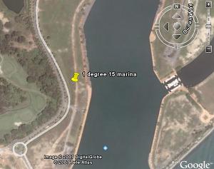
On Googles image there is no marina - and if there were it would be on land.
Singapore has reclaimed land to the extent that very few electronic charts have been annotated to show the geographical changes and the same applies to Paper charts.
Therefore, it is hoped that this new navigational aid is all that is being hyped.
Karmaladen's post provides a serious caveat.


 Linear Mode


