Join Cruiser Log Today

Reply
 
Thread Tools Search this Thread Display Modes
 
Old 09-11-2008, 11:54 PM   #1
Admiral
 
MMNETSEA's Avatar
 
Join Date: Oct 2004
Posts: 3,067
Default

Are we to be witness to another catastrophe? akin to that of the :-

Click >

Galveston Hurricane of 1900

-----------------------------------------

HURRICANE IKE LOCAL STATEMENT

NATIONAL WEATHER SERVICE HOUSTON/GALVESTON TX

419 PM CDT THU SEP 11 2008

...VERY LARGE HURRICANE IKE HEADING TOWARDS SOUTHEAST TEXAS...

GALVESTON COUNTY:

A MANDATORY EVACUATION HAS BEEN ORDERED FOR ALL OF GALVESTON

ISLAND. THIS ORDER GOES INTO EFFECT AT NOON TODAY.

SHORELINE OF GALVESTON BAY...15 TO 22 FEET

LIFE THREATENING INUNDATION LIKELY!

ALL NEIGHBORHOODS...AND POSSIBLY ENTIRE COASTAL COMMUNITIES...

WILL BE INUNDATED DURING THE PERIOD OF PEAK STORM TIDE. PERSONS

NOT HEEDING EVACUATION ORDERS IN SINGLE FAMILY ONE OR TWO STORY

HOMES WILL FACE CERTAIN DEATH. MANY RESIDENCES OF AVERAGE

CONSTRUCTION DIRECTLY ON THE COAST WILL BE DESTROYED. WIDESPREAD

AND DEVASTATING PERSONAL PROPERTY DAMAGE IS LIKELY ELSEWHERE.

VEHICLES LEFT BEHIND WILL LIKELY BE SWEPT AWAY. NUMEROUS ROADS

WILL BE SWAMPED...SOME MAY BE WASHED AWAY BY THE WATER. ENTIRE

FLOOD PRONE COASTAL COMMUNITIES WILL BE CUTOFF. WATER LEVELS MAY

EXCEED 9 FEET FOR MORE THAN A MILE INLAND. COASTAL RESIDENTS IN

MULTI-STORY FACILITIES RISK BEING CUTOFF. CONDITIONS WILL BE

WORSENED BY BATTERING WAVES. SUCH WAVES WILL EXACERBATE PROPERTY

DAMAGE...WITH MASSIVE DESTRUCTION OF HOMES...INCLUDING THOSE OF

BLOCK CONSTRUCTION. DAMAGE FROM BEACH EROSION COULD TAKE YEARS TO

REPAIR.

I have prepared a chartlet showing exactly where the eye of the storm is forecast to be by the National Hurricane Centre on the 13 September at 0600 UTC - 29 degrees North x 95 degrees West. Because the circulation is anti-clockwise the potential for a catastrophic event is rated as being probable.

Click image for larger version

Name:	Hurricane_IKE_s_eye.jpg
Views:	6
Size:	44.1 KB
ID:	611

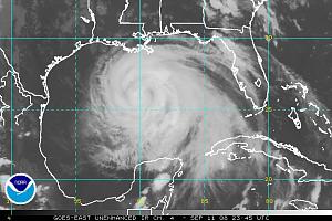
Satellite Image taken 2345 UTC 11th September - shows the storm almost filling the whole of the Gulf of Mexico :-

Click image for larger version

Name:	ir4_l.jpg
Views:	3
Size:	62.8 KB
ID:	612
__________________

__________________
MMNETSEA is offline   Reply With Quote
Old 09-13-2008, 02:34 AM   #2
Admiral
 
MMNETSEA's Avatar
 
Join Date: Oct 2004
Posts: 3,067
Default

Satellite Image taken 0145 UTC 13th September - shows the storm's eye on the doorstep of Galveston Island :-

Click image for larger version

Name:	IKE_0145_UTC_13_08.jpg
Views:	6
Size:	61.3 KB
ID:	613
__________________

__________________
MMNETSEA is offline   Reply With Quote
Old 09-13-2008, 03:57 AM   #3
Admiral
 
MMNETSEA's Avatar
 
Join Date: Oct 2004
Posts: 3,067
Default

Satellite Image taken 0315 UTC 13th September - shows the storm's northern part of the eye's wall at Galveston Island (this time, may be when the highest winds are recorded) :-

Click image for larger version

Name:	IKE_s_eye_at_Galveston_Is.jpg
Views:	1
Size:	60.3 KB
ID:	615
__________________
MMNETSEA is offline   Reply With Quote
Old 09-13-2008, 10:19 AM   #4
Admiral
 
JeanneP's Avatar
 
Join Date: Jul 2004
Posts: 2,098
Default

Here's one early report of the storm. IKE
__________________
In 1986 we went cruising for a few years. After 20 years and 50+ countries and several oceans, we are STILL "cruising for a few years".

SY WATERMELON |
MV WATERMELON (New) | Cruiser's Dictionary, free ebook

= Cruiser's Dictionary, North America,
JeanneP is offline   Reply With Quote
Old 09-15-2008, 02:35 AM   #5
Admiral
 
MMNETSEA's Avatar
 
Join Date: Oct 2004
Posts: 3,067
Default

Here is just one image of a few boats that were caught up by the surge's swirling waters north of Galveston and into Houston's bywaters :-

Click image for larger version

Name:	IKE_s_Boats.jpg
Views:	6
Size:	91.4 KB
ID:	617
__________________
MMNETSEA is offline   Reply With Quote
Reply


Currently Active Users Viewing This Thread: 1 (0 members and 1 guests)
 

Posting Rules
You may not post new threads
You may not post replies
You may not post attachments
You may not edit your posts

BB code is On
Smilies are On
[IMG] code is On
HTML code is Off
Trackbacks are Off
Pingbacks are Off
Refbacks are Off


Similar Threads
Thread Thread Starter Forum Replies Last Post
Tropical Storm Ophelia / Tropical Storm Philippe / Possible Development Sw Caribbean Synopsis…oct. 0 StormW "StormW's" Daily Weather Synopsis 0 10-03-2011 05:31 PM
Tropical Storm Ophelia / Tropical Storm Philippe Synopsis…sep. 29, 2011…issued 11:25 A.m. Edt StormW "StormW's" Daily Weather Synopsis 0 09-29-2011 03:37 PM
Hurricane Katia…tropical Storm Maria…tropical Storm Nate Synopsis…sep. 09, 2011…issued 10:25 A.m. Ed StormW "StormW's" Daily Weather Synopsis 0 09-09-2011 02:52 PM
Hurricane Katia…tropical Storm Maria…tropical Storm Nate Synopsis…sep. 08, 2011…issued 9:30 A.m. Edt StormW "StormW's" Daily Weather Synopsis 0 09-08-2011 01:47 PM
← Older Posts Tropical Storm Tomas / Central Atlantic Disturbance / Possible East Coast Storm Synpos StormW "StormW's" Daily Weather Synopsis 0 11-01-2010 03:00 PM

Our Communities

Our communities encompass many different hobbies and interests, but each one is built on friendly, intelligent membership.

» More about our Communities

Automotive Communities

Our Automotive communities encompass many different makes and models. From U.S. domestics to European Saloons.

» More about our Automotive Communities

RV & Travel Trailer Communities

Our RV & Travel Trailer sites encompasses virtually all types of Recreational Vehicles, from brand-specific to general RV communities.

» More about our RV Communities

Marine Communities

Our Marine websites focus on Cruising and Sailing Vessels, including forums and the largest cruising Wiki project on the web today.

» More about our Marine Communities


All times are GMT. The time now is 04:27 AM.


Powered by vBulletin® Version 3.8.8 Beta 4
Copyright ©2000 - 2024, vBulletin Solutions, Inc.
SEO by vBSEO 3.6.0
×