 |
 09-28-2009, 02:33 AM
|
#1
|
|
Ensign
Join Date: Nov 2005
Posts: 27
|
I know this may seem like a silly question - but how would you read the following bridge clearance sign....
----------
61
----------
62
----------
63
----------
64
<----------------here is the water line
xxx water xxxxxxx
xxx water xxxxxxx
Is this 64' 10" or 63' 10" ?
__________________
__________________
|

|

|
|
09-28-2009, 02:54 AM
|
#2
|
|
Admiral
Join Date: Oct 2004
Posts: 3,067
|
Before answering this good question, what was the tidal range, minimum tide and max tide in feet with their times ?
Once those are given, the answer to the question should be apparent.
BTW - the Hunter 40.5 Legend's, bridge deck clearance is given as 62'9''
__________________
__________________

|
|
|
|
|
09-28-2009, 03:32 AM
|
#3
|
|
Ensign
Join Date: Nov 2005
Posts: 27
|
Our 1997 Hunter 405 Legend has a mast height of 64'4" with the antennae.....
I don't know why your request for info helps answer this specific question - I'm asking if you approach a bridge with that indication, what would you say the bridge clearance was at that particular time?
__________________
|
|
|
|
|
09-28-2009, 08:49 AM
|
#4
|
|
Admiral
Join Date: Oct 2004
Posts: 3,067
|

Quote:
Originally Posted by karenmmc

I know this may seem like a silly question - but how would you read the following bridge clearance sign....
----------
61
----------
62
----------
63
----------
64
<----------------here is the water line
xxx water xxxxxxx
xxx water xxxxxxx
Is this 64' 10" or 63' 10" ?
---------------------------------------------------------------------------------------------------------------------------------------
Our 1997 Hunter 405 Legend has a mast height of 64'4" with the antennae.....
I don't know why your request for info helps answer this specific question - I'm asking if you approach a bridge with that indication, what would you say the bridge clearance was at that particular time?
|
The answer is neither 64' 10" nor 63' 10" . The bridge deck clearance is close to 64' 4" in your example. In other words - The skipper's discretion is required to procede. It is very important to know the heights of the tides at the time that the boat is going to pass under the bridge and whether the tide is falling or rising , and most important of all, at what speed.
In some areas of the world where there huge tidal ranges - the speed of an flood tide can make what appears to be a simple exercise in passing under a bridge into a white knuckle event, where steering itself can be very difficult.
__________________
|
|
|
|
|
09-28-2009, 12:13 PM
|
#5
|
|
Ensign
Join Date: Nov 2005
Posts: 27
|
Hi - I'm not trying to belabor the point, but I don't think you're understanding my question -
Assume I'm motoring towards that specific bridge - binoculars in hand - and the given indication is what I'm seeing. You see where I've marked the water - What is the reading?
At that specific moment.
I'm just trying to verify that I need to see the ENTIRE 64' "band" to have 64'0". (Not like a standard tape measure where you see the "foot" mark and proceed up in length).
Am I reading 64' at the line on top of the 64 or at the line on the bottom - I guess that's the real, simple question.
(This is all just an example - I know I need to see 65' before I really want to attempt the bridge).
__________________
|
|
|
|
|
09-28-2009, 12:36 PM
|
#6
|
|
Retired Mod
Join Date: Mar 2007
Home Port: Durban
Posts: 2,984
|
I was confused at first but get it now.
Good question!
 : Most sections |
|
|
|
|
09-28-2009, 01:10 PM
|
#7
|
|
Admiral
Join Date: Jul 2004
Posts: 2,098
|
Where are you seeing height lines like that? They're usually in 2-foot increments (58, 60, 62) with a line between each, indicating the fill-in odd number.
The board tells you that you have 64' plus some if your description is not exact (in other words, the numbers are as I mention above). The height must be readable, and as the tide rises the line below the number is going to be obscured by water.
(most height boards I recall seeing have the number between a broken line, like this -64- indicating that the 64 is ON the 64' line).
Sometimes it helps with reasoning on some of the less-maintained sections of the ICW to see what the charts says maximum vertical clearance is, and you shouild know the state of the tide, though this remains an approximation in cases of significantly high water or low water due to rain or drought.
Clear as mud?
J
|
|
|
|
|
09-28-2009, 01:29 PM
|
#8
|
|
Ensign
Join Date: Nov 2005
Posts: 27
|
How about this -
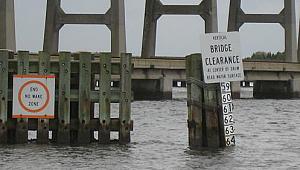
It's the Beaufort, NC high rise.
Does it read just 64' ?
OR, does it read 64' plus about 10"?
__________________
|
|
|
|
|
09-28-2009, 01:48 PM
|
#9
|
|
Admiral
Join Date: Jul 2004
Posts: 2,098
|
Darn! That's a messy one, and the board is tilted. I'd go with JUST 64'. Bah! Not a good sign, IMO.
We're headed that way right now, I think I'll do a little close-eyed scrutiny of the bridge boards. Thank you for posting the question and the photo.
|
|
|
|
|
09-29-2009, 03:51 PM
|
#10
|
|
Admiral
Join Date: Jul 2004
Posts: 2,098
|
If it's the Cedar Point Bridge, we just went under it, and the board looks pretty sad. The chart says vertical clearance is 65 feet, the board shows 64 feet with lots of growth above and below the line under the "64". Beats me, I'd say it's 64 feet at the underline, so something is wrong, perhaps the slope of the board is distorting the height reading?
PS. Just reviewed your photo, it's not the same bridge, but another sad sign. We're moving, so can't pull off the photo and post it before I lose a connection again. Try tonight.
j
|
|
|
|
|
09-29-2009, 10:20 PM
|
#11
|
|
Ensign
Join Date: Nov 2005
Posts: 27
|
Jeanne, thanks for the reply - I've always called the bridge in the photo the Beaufort high rise. It is actually US 70 going thru Beaufort, NC and is just north of Radio Island and Taylor's creek. The day I shot that photo (last Saturday) - the water was high (and it several hours to high tide when I snapped the photo). With our ridiculously tall height, we turned around and went thru the bascule bridge to the east. I just wanted to make sure I was reading the sign correctly - I agree, they're not the greatest! Maybe we'll see you "out there" sometime!
__________________
|
|
|
|
|
09-30-2009, 10:27 AM
|
#12
|
|
Admiral
Join Date: Jul 2004
Posts: 2,098
|
Sorry, will have to wait for pictures. It's COLD this far north, and so we're using our daylight to move further south. And to think, it was downright balmy just three days ago in Virginia! #%Q# Canadian north winds!
__________________
|
|
|
|
|
|
Currently Active Users Viewing This Thread: 1 (0 members and 1 guests)
|
|
|
 Posting Rules
|
You may not post new threads
You may not post replies
You may not post attachments
You may not edit your posts
HTML code is Off
|
|
|
|
 Recent Threads
 |
|
|
|
|
|
|
|
|
|
|
|
|
|
|
|
|
|
|
|
|
|
|
|


 Linear Mode


